
0
Owner's of the iOptron Telescope 6002 gave it a score of 0 out of 5. Here's how the scores stacked up:


Having trouble setting up or making it work? Email us at 900X70@ioptron.com We’ll be glad to help!
7
2. Understanding Celestial Motion and
Coordinates
Understanding where to locate celestial objects and
how these objects move through the sky is
fundamental to fully appreciating astronomy as a
hobby. Most amateur astronomers use the same
visual path (or star-hopping) method for locating
celestial objects. To do this they use maps of the
sky or an astronomy program that identifies bright
stars and constellations of stars that serve as
"roadmaps" and "markers" in the sky. These visual
reference points guide amateur astronomers in
their search for astronomic objects and although
the visual path method is the preferred
approach—giving thought to whether or not to use
circles of digital coordinates for locating objects is
desirable as your telescope offers this function. Be
warned however, when compared with a visual path
approach, looking for objects using circles of digital
coordinates requires a greater investment in terms
of patience and time in order to achieve a more
precise alignment of the telescope's polar axis on
the celestial pole. This is partially why the visual
path approach is preferred since it’s the simplest
(and quickest) way to get started.
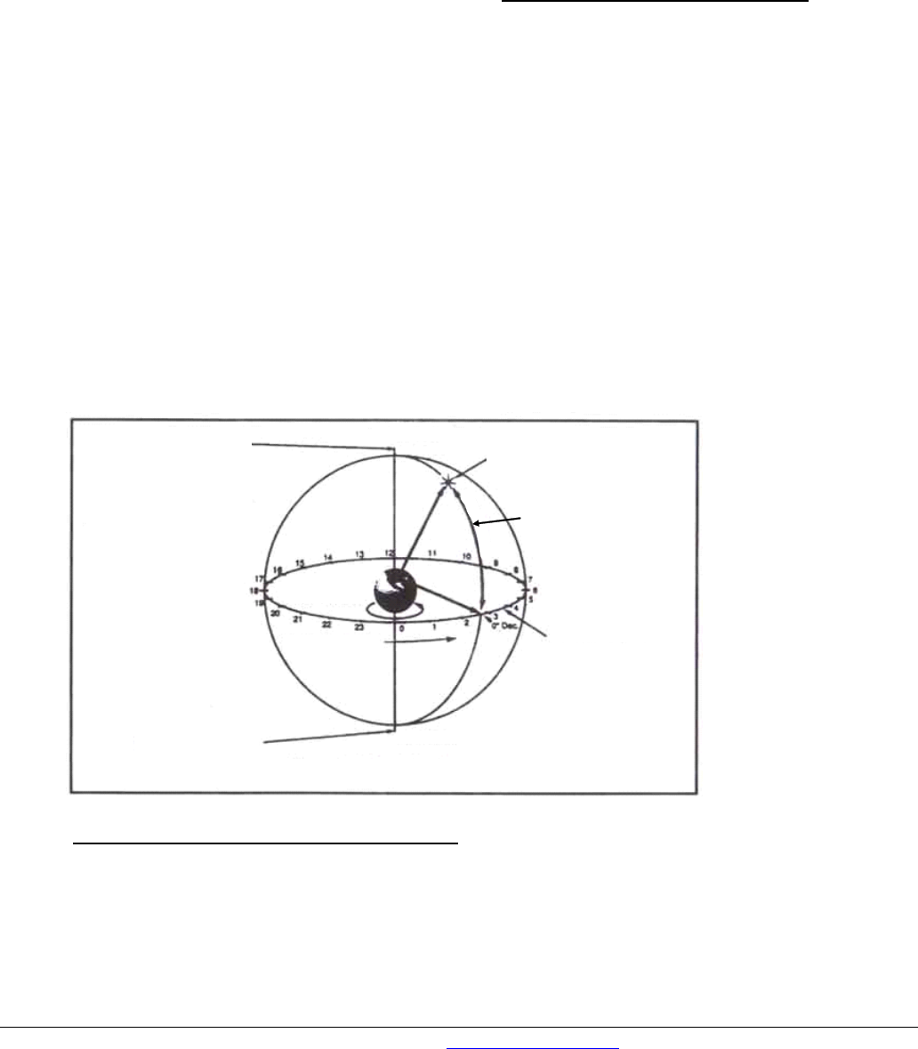
Understanding how astronomic objects move
Given the earth's rotation, celestial bodies (stars)
appear to move from east to west along a curved
trajectory across the sky. The trajectory that they
follow is known as the right ascension line (R.A.).
The angle of the trajectory that they follow is known
as the declination line (Dec.). The right ascension
and the declination form a system that is similar to
the terrestrial system of latitude and longitude.
In the system of R.A. and Dec. coordinates, stars
are projected onto the "celestial sphere", i.e. onto
the imaginary sphere where all of the stars appear
to be located.
Understanding celestial coordinates
In the system of celestial coordinates, the poles are
defined as being the two points where the earth's
rotation axis, when prolonged infinitely to the north
and to the south, intersects with the celestial
sphere. Consequently, the celestial North Pole is
the point in the sky where the prolongation of the
earth's axis passing through the North Pole
intersects the celestial sphere. In fact this point in
the sky is located close to the North Star or pole
star (Polaris).
So-called "longitude lines" are drawn on the earth's
surface between the north and south poles. In the
same way, "latitude lines" are drawn along an
east-west direction, parallel to the earth's equator.
The celestial equator is simply a projection of the
earth's equator into the celestial sphere. Just like
on the earth's surface, imaginary lines have been
drawn on the celestial
sphere to form a grid of
coordinates. The
positions of the stars
on the earth's surface
are specified by their
latitude and longitude.
The celestial
equivalent to terrestrial
latitude is called
"Declination" or simply
"Dec", expressed in
degrees, minutes, and
seconds north (“+”) or
south ("-") of the
celestial equator.
Consequently any
point located along the
celestial equator (e.g.
passing through the constellations of Orion, Virgo
and Aquarius) is specified by its declination of
0º0’0”. The declination of the North Star or pole star
located very close to the North Celestial Pole is
+89.2º.
The celestial equivalent to terrestrial longitude is
called "Right Ascension" or "R.A.", expressed in
hours, minutes and seconds from a "zero" R.A. line
defined arbitrarily and which passes through the
Celestial North Pole
(close to the North Star
(Polaris))
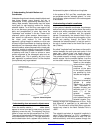
Star
Declination
Earth's rotation
Right ascension
Celestial equator
Celestial South Pole
Figure 2: Celestial Sphere


Find Your Products By Category
Please Login
